Boundary Surveys
Also known as a re-peg, a boundary survey is the reestablishment of the original pegs on a property, so that that the owner can confirm the true location of the boundaries.
Common reasons for repegs
- renewing fences
- constructing buildings near boundaries
- settling disputes with neighbours
In accordance with the land boundaries act of 1841, all land parcels require demarcation by visible landmark that creation. These marks usually consist of pegs at each corner designating the legal boundaries as defined by title deed.
For residential lots, square wooden pegs are used with a plate fixed on top with the adjoining lot numbers shown.
Over time, these pegs are often destroyed through construction work in the vicinity of the lot corners, such as with the erection of fences. A re-peg survey is the reestablishment of those original pegs that the owner can confirm the true location of the property boundaries. Re-pegs are often required for the renewing of fences or the construction of buildings near boundaries.
Licensed Registered Surveyors
Performing a boundary survey or re-peg can only be performed by a licensed registered surveyor who is qualified under the Act. If required, a re-peg certificate or plan showing the marketplace and location of buildings or structures on or near the boundary can be prepared under regulation 25A of the Licensed Surveyors Regulation 1961. Land Surveyors Perth are also specialist feature contour, engineering and subdivision surveyors.
To book a survey or get a free quote, please fill in the contact form.
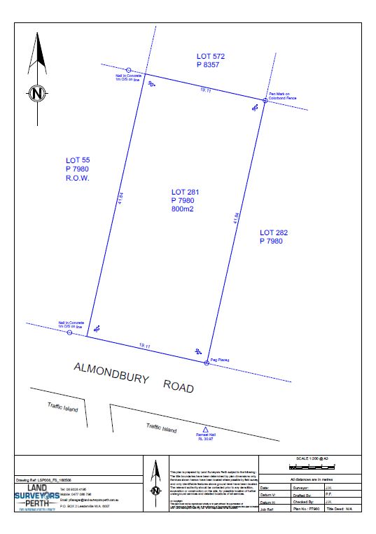
Below is an example of a certificate as outlined above.
Get a Free Surveying Quote
We’ll get back to you within 24hrs
"*" indicates required fields
Surveyor News
FAQS
Related Project
-
Clients: Civmec
Scope: Civil and Mechanical
Project Duration: 3 months
Start Date: Complete
Project Overview
This Project consisted of detailed surveys of the existing crushers 1,2 and 3 to facilitate future upgrade works
Scope of Works
- Detailed plan production of existing plant
- Various ground slabs and footings

No project for this service.