Surveyor News
-

Licensed Surveyor
What is a licensed surveyor?
The work of a surveyor is highly skilled. Licensed surveyors are qualifed and trained to survey and re-establish property boundaries.
A licensed surveyor provides certainty about the location and extent of your land, and helps protect you from boundary disputes and expensive litigation.
When you use a licensed surveyor, he/she will provide you with a sketch or plan of the land with a certifcate within 30 days of completing the survey. This ‘reg25A’ certifcate is your legal protection.
It is against the law for anyone who is not a licensed surveyor, registered with the Land Surveyors Licensing Board of Western Australia, to survey new boundaries or re-establish old ones.
A wall or even a house built in the wrong place – even if it’s only a few centimetres out, could have severe legal and fnancial consequences.
Be certain you are dealing with a licensed surveyor
In Western Australia licensed surveyors are regulated by the Licensed Surveyors Act 1909 which is administered by the Land Surveyors Licensing Board.
The Board is responsible for examining and registering land surveyors, ensuring their standards meet the expectations of the community and authorities, and for providing a fair, open and accessible process to deal with complaints.
To check if a surveyor is registered in Western Australia and holds a current practising certifcate go to www.lslb.wa.gov.au or call 9273 7104.
-

Leica Viva GS15 GPS System
A GPS system is commonly used for survey and set out covering all aspects of survey requirements thereby making it another critical piece of equipment for surveyors. A typical GPS setup may consist of a Leica Viva GS15 base station and rover system, although various other Leica GPS combinations may be used to deal with connection or range issues.
All Leica GPS combinations have the ability to interchange seamlessly, meaning the correct combination can be found without delay. Working off a GNSS (Global Navigation Satellite System), Land Surveyors Perth only use equipment offering the best range of GPS coverage available.
Clever design and compact equipment by Leica allow for a full GPS system to be stored in a portable protective case not much bigger than the average briefcase. This allows for surveyors to maintain a high degree of mobility in cases where multiple GPS set-ups may be required on a large site. The accuracy and mobility of the Leica Viva GS15 GPS system provides Land Surveyors Perth particular advantage in the sectors of cadastral, residential and commercial surveys.
The mobility of the equipment and the very short time needed to set it up allows the surveyor to spend the most time possible where it matters, completing a comprehensive job setting out around a site or taking a survey of a site. All work on site is completed wirelessly as the base, rover and controller communicate via Bluetooth.
The Leica SmartWorx Viva software package in the Leica GS15 range is another feature that aids timely and precise work. Import and export of plans, calculations and point lists via use of USB cable or thumb drive connection means that the surveyor can set up for work or export finished work in a matter of seconds. The easy to navigate menus on the handheld portable controller also allow the surveyor be very time efficient on site.
Land Surveyors Perth continually invests in the latest Leica GPS systems available enabling a time and cost effective surveying solution for clients – large and small.
-
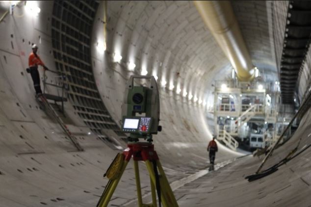
What is Engineering Surveying?
Engineering Surveying is the broad term used to describe the work of surveyors on civil engineering jobs. The role of an engineering surveyor is a lot larger than simply set out for construction of a structure and survey pick-ups. Engineering Surveyors will usually be the professionals who first examine a finished design for a project and often will identify any design or practicality issues.
Need an engineering survey? We provide expert service! Visit our Engineering Surveys Page.
Engineering Surveyors will use a wide range of instruments to assist them with their on-site work. The most common of these will be the Total Station, GPS and Dumpy Level or Digital Level. At Land Surveyors Perth, Leica is the manufacturer of all equipment the company uses and this provides surveyors with seamless interaction between all instruments.
The surveyor receives the plans for the job and after review, will begin to draw them on a CAD based computer programme. During the drawing and calculation stage, the surveyor will be able to identify any issues in the design or any they see in terms of the practicalities of building the structure. If any issues are found, the surveyor will liaise with the engineering team and help in a preparation of a technical query.
Once the design is plotted and calculations are completed, the work on site will begin. The surveyors will first establish a network of control points around the site in a position predetermined with engineers and supervisors on site. The control points need to be in useful, safe and accessible areas but also in areas where they will not be disturbed.
When the work commences, the surveyors always communicate with the site supervisor and discuss which is the best and safest way to proceed with the setting out or survey task at hand. Land Surveyors Perth staff bring a wealth of knowledge to construction sites and the coordination between surveyor and supervisor always ensures that the most practicable solution to a setting out or survey task is always adhered to.
Once all the survey data has been recorded, the Engineering Surveyor will return to the office to process the data, complete calculations and finally complete the as-built documentation. The as-built documentation may be presented on a drawing, spreadsheet or a combination of both.